Resilient Intelligent Infrastructure:
Perception, Robots, and Auditable Decisions Across Scales
Connecting Physics-Grounded Field Robotics, Cooperative Roadside LiDAR, and Source-Traced Geospatial AI with Public Agencies
Bo Shang, Ph.D.
Postdoctoral Associate · Department of Civil & Environmental Engineering
Maryland Transportation Institute (M-TRAIL), University of Maryland, College Park
bshang@umd.edu · cnpcshangbo.github.io
How Can the Built Environment Perceive Itself Across Scales?
Core Question: At every spatial scale—from a steel bridge girder (~m) to an urban intersection (~100 m), a highway corridor (~km), and a city network—what can be observed, where do sensors fail, and what decisions become auditable?
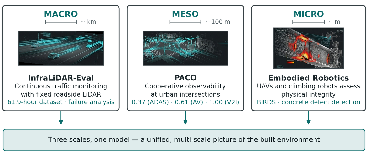
City & Network Synthesis (UMD M-TRAIL): Fixed sensors provide persistent macro/meso observability; embodied robots provide micro-scale physical access; CERRA + LLM-SUMO + feasibility-preserving optimization turn evidence into agency decisions.
From Physics-Grounded Flight Control to Multi-Scale Infrastructure AI
1. Ph.D. & UC Merced
2013 – 2020
- Fractional-order UAV visual servoing (Nonlinear Dynamics '19)
- Sampling-period margin analysis (ASME IDETC '17)
- SmartCaveDrone 3D cave mapping (ICUAS '17)
2. Missouri S&T Postdoc
2020 – 2022
- BIRDS flying + clamping bridge inspection robot
- U.S. Patent 12,296,994 B2 ('25)
- ASCE 2025 Charles Pankow Award team
- INSPIRE-024 & PHMSA deliverables
3. CCNY / CUNY Postdoc
2022 – 2026
- Concrete defect robot + 3D mesh (IEEE T-ASE '25 / IROS '25)
- PACO & safety auditing (CVPRW '26, MobiSPC '25)
- Street View freight AI (IEEE OJ-ITS '26)
4. UMD M-TRAIL Postdoc
Jul 2026 – Present
- Build & operate CERRA geospatial AI platform
- Integrate LLM-SUMO digital twin (Oct '26)
- PAR auditability standard & IBM Heron VRP validation
Seminar Roadmap
Part I: Micro-Scale (~m) — Fractional-Order UAV Control, BIRDS Flying-Clamping Robot, & CCNY Concrete Defect Analytics
Part II: Meso-Scale (~100 m) — PACO Cooperative Observability (0.37 / 0.61 / 1.00) & CVPRW '26 Safety Auditing
Part III & IV: Macro (~km) & City Scale — InfraLiDAR-Eval (61.9 h), IEEE OJ-ITS Freight, CERRA, LLM-SUMO & Quantum VRP · Part V: 5-Year Agenda & Teaching
Physics-Grounded Control & Embodied Inspection Robots
Operating under bridges, near concrete columns, and on steel girders where GPS is denied, sampling periods fluctuate, and inspectors need quantitative 3D evidence.
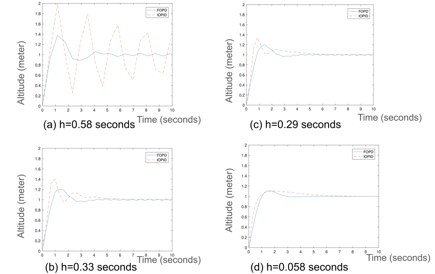
Max stable vision sampling period: FOPD vs. IOPID (+71%)
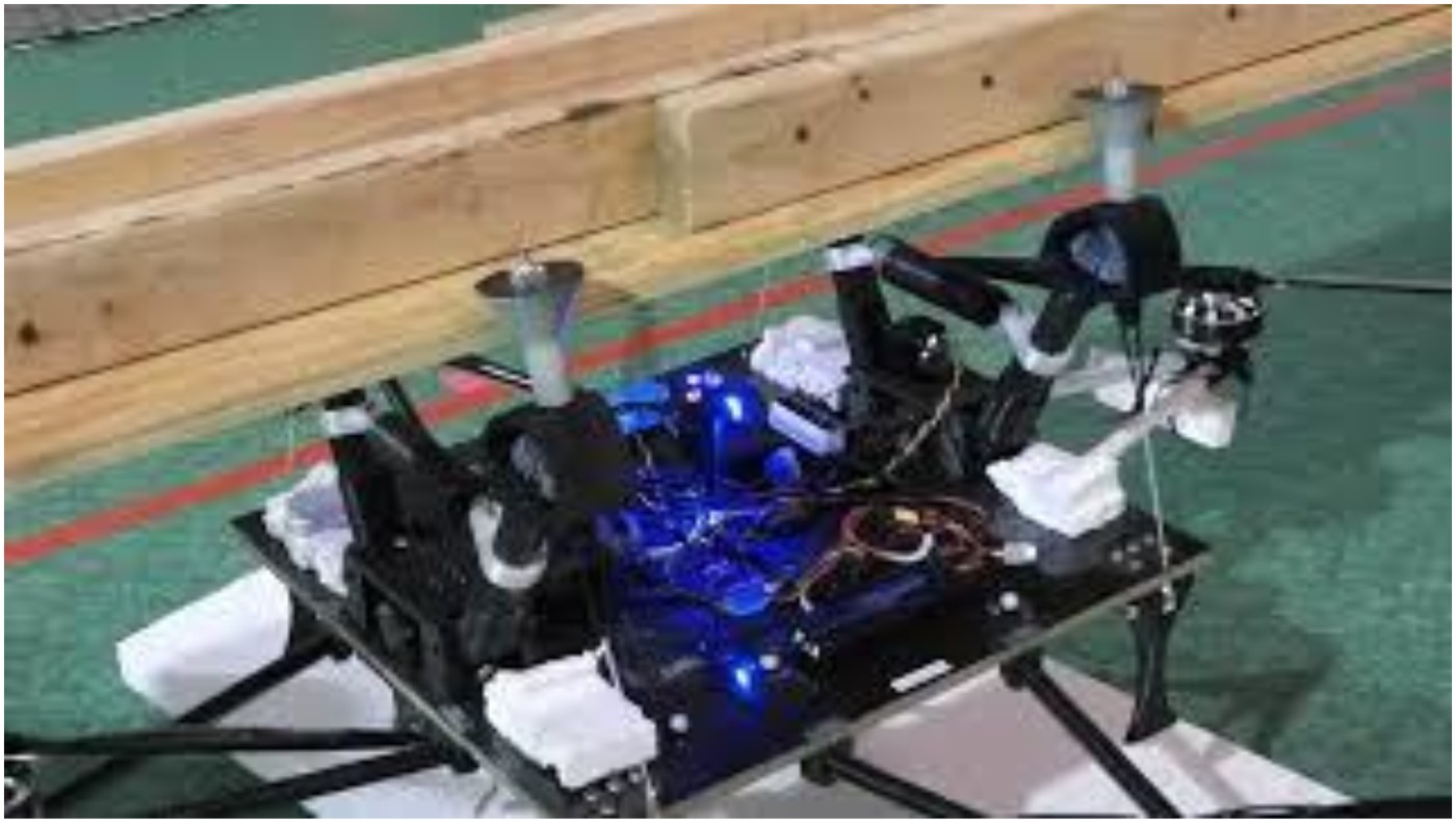
BIRDS flight + surface-traverse bridge robot (ASCE Pankow '25)
Concrete defect robot, AWS CNN & 3D mesh localization
Fractional-Order Visual Servoing Control of Quadrotor UAS
Why Visual Servoing Breaks Near Structures
- Under-bridge flight denies GPS and introduces aerodynamic turbulence & wind gusts.
- Onboard vision processing creates larger, variable sampling periods that destabilize integer-order PID loops.
- Target loss from camera FOV causes immediate mission failure.
Iso-Damping Fractional-Order Design (FOPD)
- Extends derivative/integral action to real orders (λ, μ), enforcing zero phase slope at gain crossover:
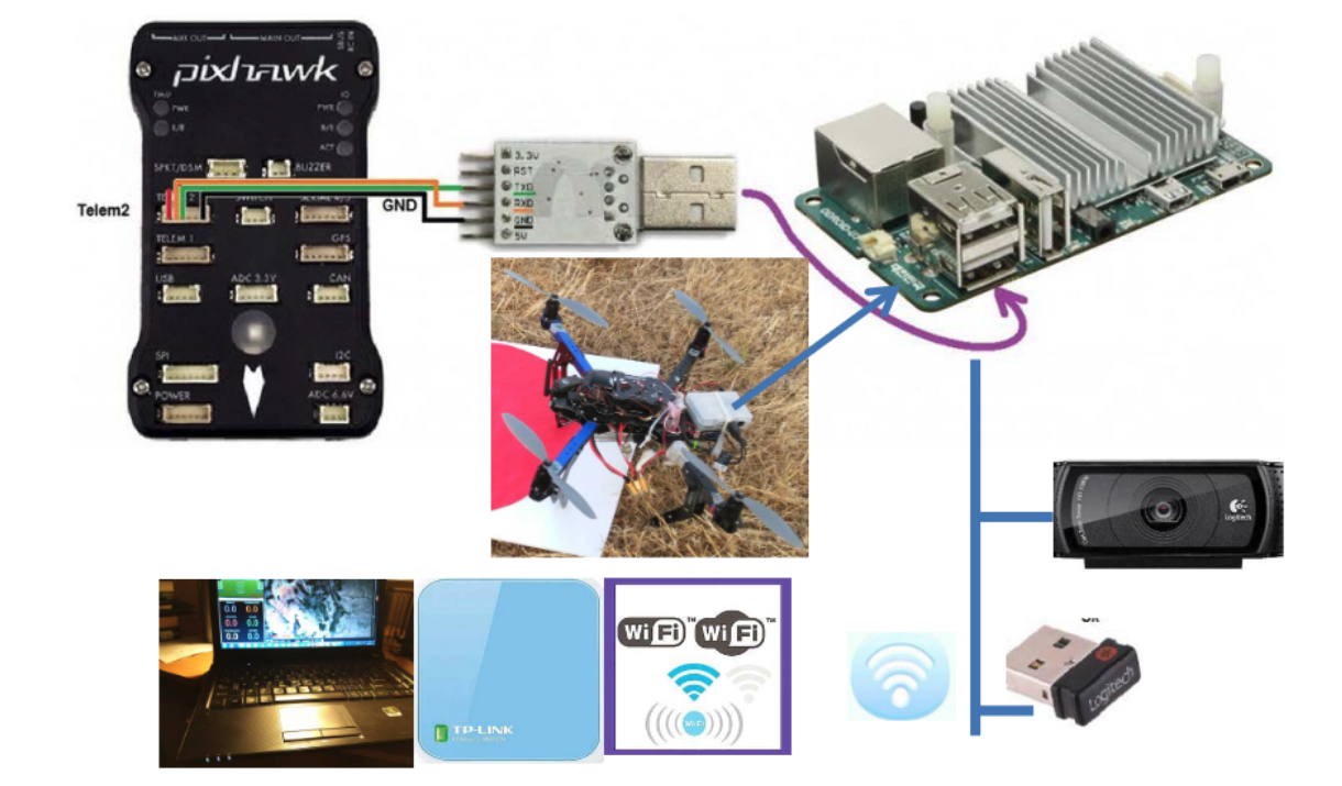
d arg G(jω)/dω = 0. - Built reproducible Simscape & OS4 benchmarks plus custom Pixhawk + embedded Linux + ground HSV tuning stack.
- Extended to RGB-D cave SLAM in SmartCaveDrone (ICUAS '17).
Sampling-Period Tolerance & Gain-Invariance Under Vision Latency
0.933 s vs. 0.546 s (+71%)
Maximum stable sampling period achieved by FOPD vs. integer-order PID (ASME IDETC 2017), tolerating lower-rate onboard vision.
20% Flight Error Reduction
Outdoor and indoor precision hovering experiments showed 20% lower tracking error and flatter ITAE growth across sampling periods.
Design Principle Carried Forward
Sampling period, sensor geometry, and actuation margin are explicit design inputs—not noise to be averaged away downstream.
BIRDS: Hybrid Flying & Surface-Traversing Bridge Inspection Robot
Operational Motivation & System Concept
- 42% of U.S. bridges are 50+ years old; snooper trucks block lanes and free-flying UAVs drain batteries fighting under-deck wind.
- BIRDS flies into position, clamps onto an I-girder bottom flange, shuts down rotors, and wheels along the beam for close-range sensing.
Patented Hardware & National Recognition
- Co-inventor: U.S. Patent 12,296,994 B2 (granted May 2025).
- Selected for the ASCE 2025 Charles Pankow Award for Innovation (Missouri S&T, PI: Prof. Genda Chen).
- Documented in INSPIRE-024 Final Report (2024) & PHMSA CAAP Pipeline Robotics Report (2022).
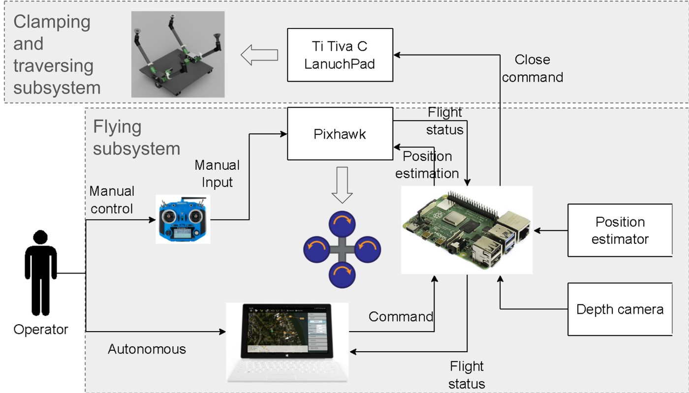
Non-GPS Girder Detection, Asymmetric Clamping & Flange Traversal
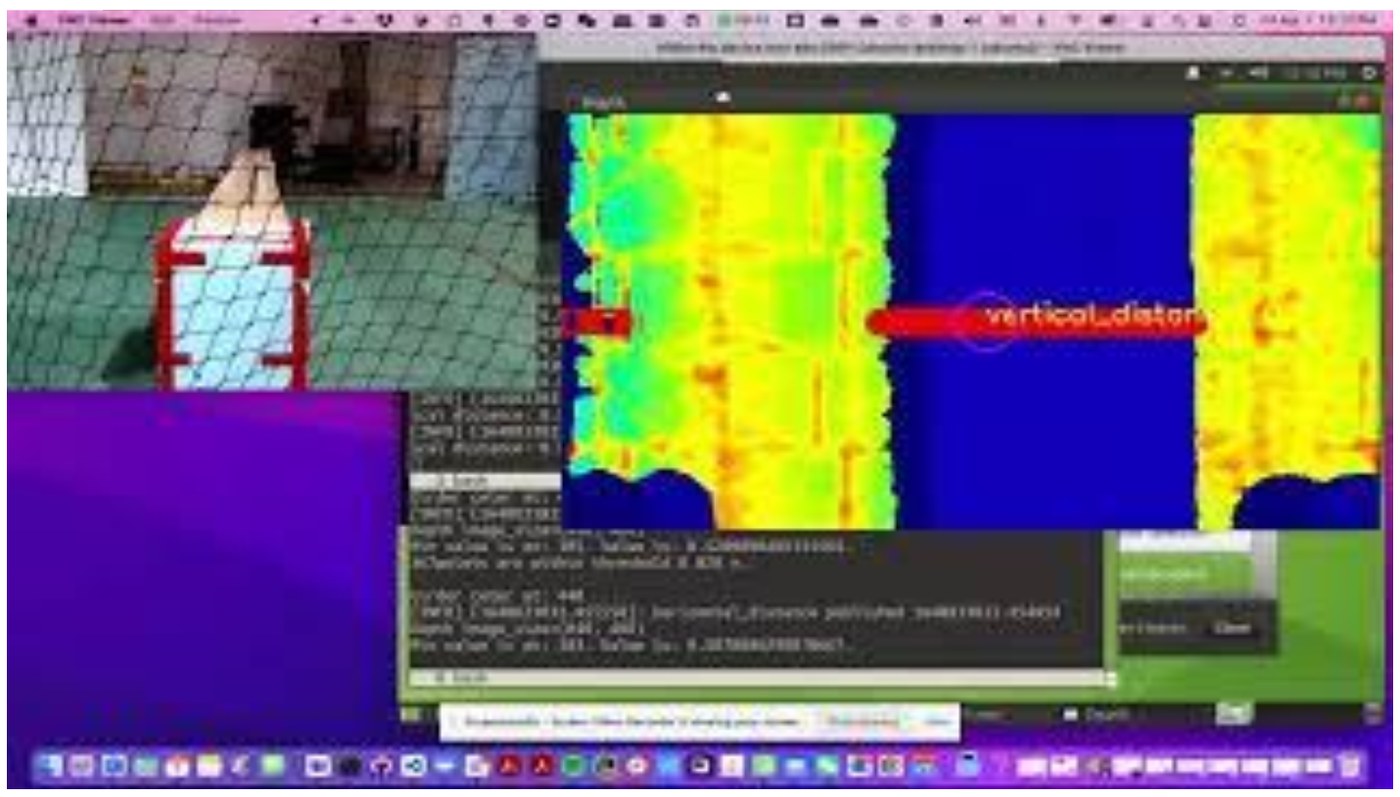
Edge Guidance & Perching Mechanics (ROS · NVIDIA Jetson · Raspberry Pi)
- RGB-D Girder Perception: Segments steel I-girder flange edges, centerline, heading, and vertical clearance onboard without GPS; paired with CFD ceiling-effect analysis (IWSHM '21).
- Safety-Asymmetric Clamping: Closes in 1.3 s upon reaching contact clearance threshold to secure attachment under wind sway, with 8.5 s controlled release and wheeled flange traversal.
Robotic Inspection & 3D Structural Defect Localization
Separate CUNY Climbing-Robot Workflow
- Developed at CCNY Robotics Lab (with J. Feng & Prof. J. Xiao)—distinct robot and codebase from BIRDS.
- Built custom iOS operator app for climbing-robot control and live field inspection review.
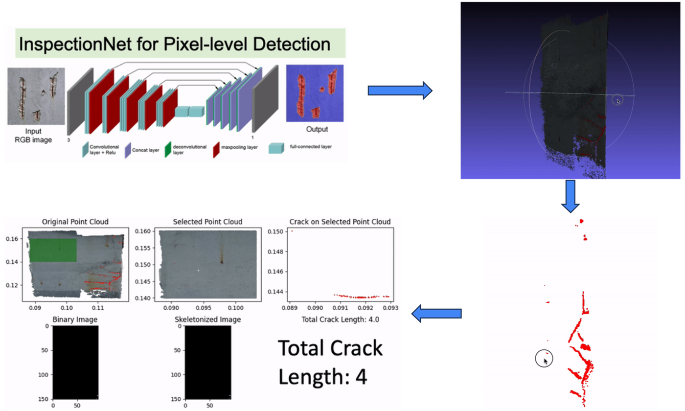
- Streams imagery to AWS for pixel-level CNN segmentation of cracks, spalling, and stains.
From 2D Masks to Metric 3D Geometry
- Registers segmented defects onto WebODM 3D point clouds and meshes.
- Skeletonizes crack topology to compute physical crack length and location in structural coordinates.
- Published in IEEE T-ASE (2025) & presented at IEEE IROS 2025.
Structure-Scale 3D Defect Mapping & Multimodal NDT Synthesis
Solving the "Thousand-Image" Bottleneck
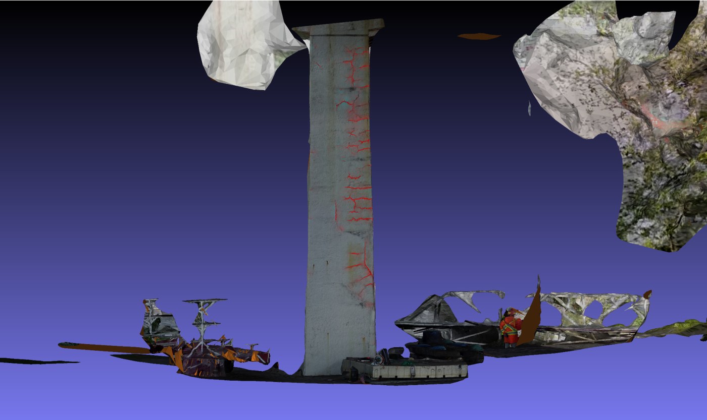
- Raw drone and climbing-robot surveys generate thousands of overlapping close-up photos that inspectors cannot audit frame by frame.
- Projecting segmented cracks (red) onto a full 3D bridge-column mesh preserves structural context for cycle-over-cycle comparison.
Complementary Multimodal NDT Record
- Thermal IR: Code-specified passive vs. active thermography for RC deck delamination (JCSHM, 2025).
- Acoustic Impact-Echo: Contrastive learning for concrete slab defect mapping (CBM, 2025).
- Aerial NDT&E synthesis (Materials Evaluation, 2023).
Cooperative Intersection Observability & VRU Safety
Quantifying why vehicle-mounted sensors hit a hard geometric occlusion ceiling in urban intersections—and building auditable roadside LiDAR intelligence.
PACO scene observability: 120° ADAS vs. 360° AV vs. Roadside V2I
68 min of real multi-class NYC trajectories at 10 Hz
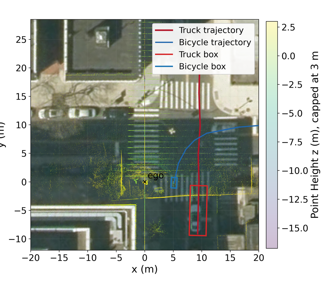
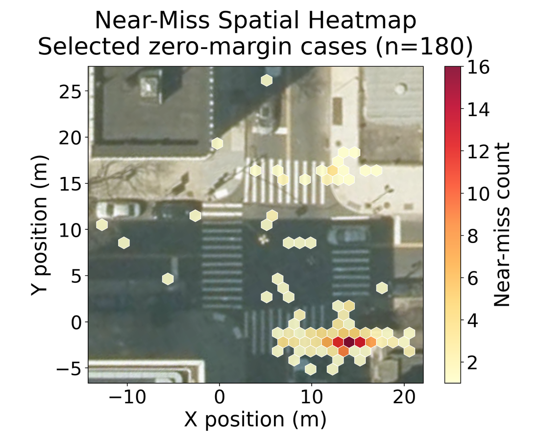
Auditable zero-margin conflict mapping (CVPRW DriveX '26)
NYC Urban Intersection Testbed & Cross-Configuration Portability
24/7 Multimodal Intersection Deployment
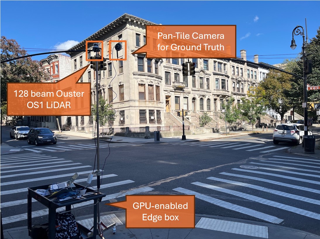
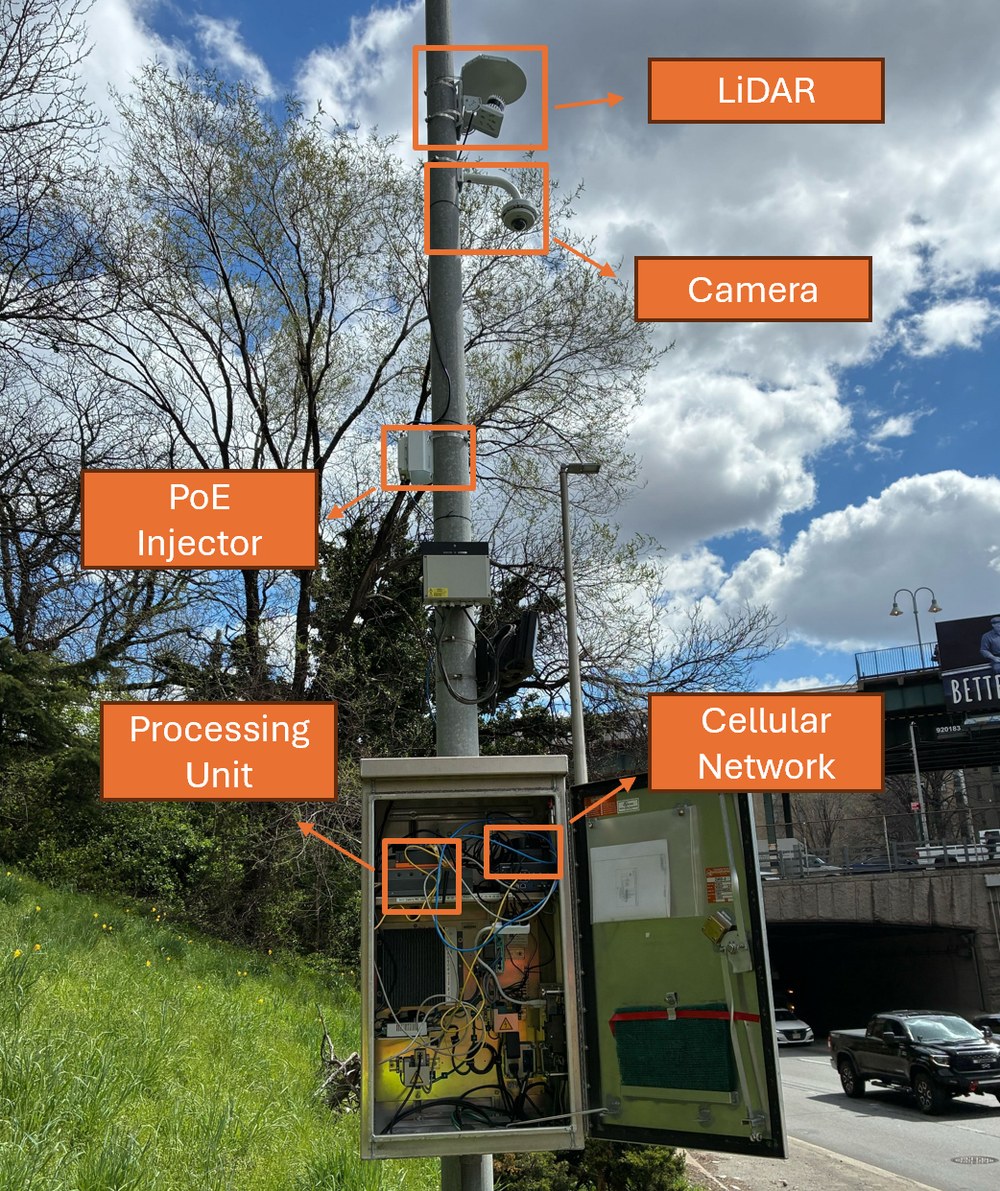
- Signalized NYC testbed (Convent Ave & W 141st St) equipped with elevated 128-beam Ouster OS1-128 LiDAR, pan-tilt RGB camera, and edge GPU unit.
- Captures unoccluded oblique 3D trajectories of vehicles, cyclists, and pedestrians unaffected by nighttime glare or shadows.
Sensor Synchronization & Beam-Count Scaling
- Engineered clock-drift synchronization, 2D–3D extrinsic calibration, background subtraction, and site-portable config layers.
- Quantified how LiDAR beam count (128 → sparser units) governs VRU detection recall (MobiSPC '25; U.S. DOT Report DOT 91974).
PACO: Parametric Assessment of Cooperative Observability
5-Stage Parametric Evaluation Pipeline
- Ego Instantiation: Place virtual onboard sensors on real vehicle trajectories.
- Sensor Coverage: Compute parametric horizontal FOV & range sectors.
- Occlusion Resolution: Ray-tracing-free angular-wedge shadow model.
- Cooperative Augmentation: Fuse ego + elevated roadside V2I LOS.
- Multi-Scope Metrics: Scene-wide vs. active conflict-partner recall.
Empirical Trajectory Foundation
- Driven by 68 minutes (40,793 frames at 10 Hz) of dense multi-class NYC intersection trajectories.
- Evaluates exact line-of-sight geometry rather than synthetic empty-road assumptions.
- Accepted at TRB Annual Meeting; in preparation for IEEE T-ITS.
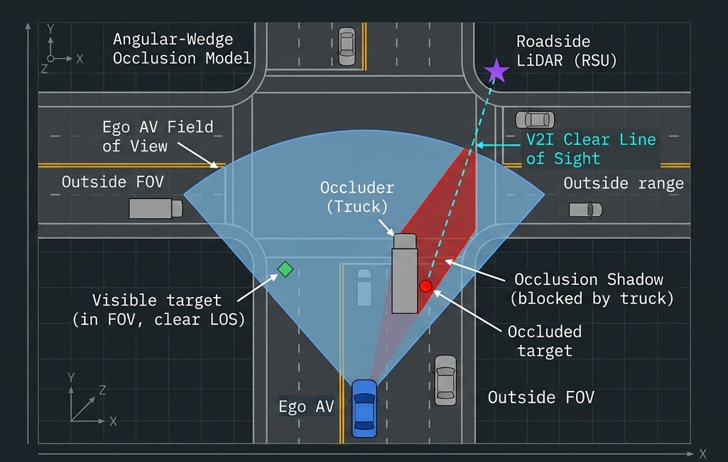
The Observability Gap: Occlusion—Not FOV—Is the Binding Constraint
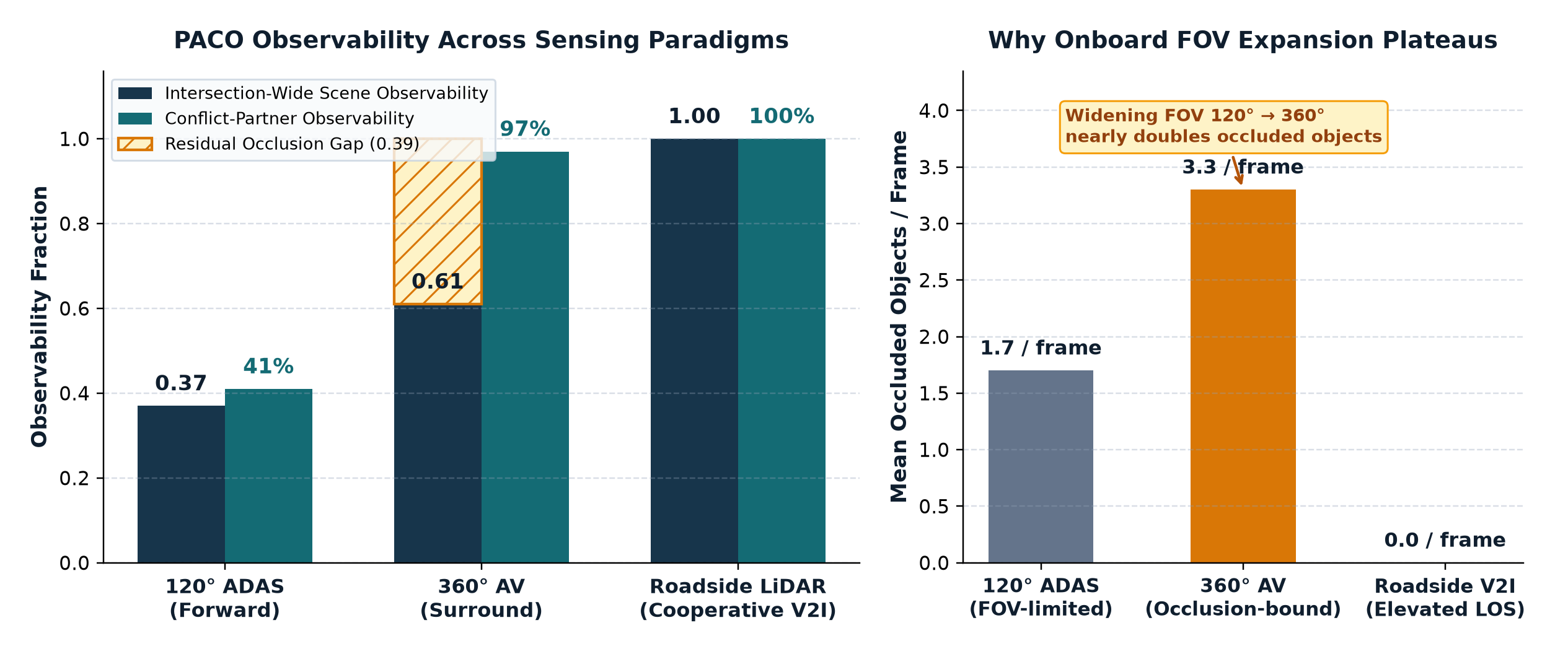
Mathematical Necessity of Infrastructure Sensing: Expanding vehicle FOV from 120° ADAS (0.37) to 360° AV (0.61) still leaves 39% of the intersection scene unobservable—and occluded objects double from 1.7 to 3.3 per frame. Only elevated V2I LiDAR closes the gap to 1.00.
Auditable Cooperative Safety Auditing at Urban Intersections
From Raw Point Clouds to Auditable Near-Miss Evidence
- Stabilizes fine-tuned CenterPoint 3D tracks with dynamics-aware Kalman smoothing and human-in-the-loop QA to audit cooperative V2X safety.
- Isolates n = 180 zero-margin near-miss events at crosswalk/turn hotspots; distinguishes benign lateral proximity from sub-second longitudinal collision risk (TTC ≈ 1.08 s valley in heavy-truck vs. bicycle conflict).
Continuous Highway Sensing & Scalable Urban Freight
Why moving-vehicle benchmarks fail on stationary elevated highway sensors—and how domain-specific LiDAR and Street View pipelines scale across corridors.
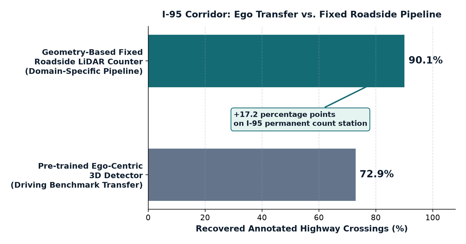
I-95 crossing recovery: fixed-sensor pipeline vs. ego detector
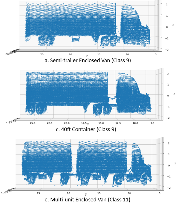
InfraLiDAR-Eval continuous dataset across 743 raw sessions
City-scale fine-grained truck sensing from Street View + VLMs
Why Ego-Centric Driving Benchmarks Do Not Transfer to Fixed Highway LiDAR
The Viewpoint Domain Gap (I-95 Permanent Count Station)
- Ego-centric benchmarks (Waymo, nuScenes) assume ground-level horizontal scans.
- Under elevated oblique highway viewing, a pre-trained ego detector recovered only 72.9% of annotated crossings vs. 90.1% for our geometry-based roadside pipeline.
InfraLiDAR-Eval: 61.9-Hour Pipeline & Roadside Failure Taxonomy
4-Stage End-to-End Architecture Across 61.9 Hours (743 Raw Roadside Sessions)
1. Raw Ingestion (lane ROIs & crossing lines) → 2. Filtering (strict 0.10 m ground clearance & seeded DBSCAN) → 3. Cross-Lane Arbitration (trajectory linking & duplicate suppression) → 4. Sparse-to-Dense FilterReg Multi-Frame Registration.
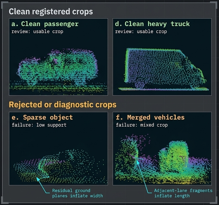
Drive-By Urban Freight Sensing & Training-Free VLM Classification
Drive-By Urban Freight Sensing (IEEE OJ-ITS 2026)
- Fixed sensors cover key corridors, but freight planners also need city-wide curb and arterial truck distributions without installing hardware on every block.
- Developed a deep-learning pipeline for large-scale, fine-grained truck body classification from Google Street View imagery.
- Turns opportunistic street-level imagery into scalable freight exposure maps across urban neighborhoods (open access, Sept 2026).
Bridging the LiDAR Modality Gap with VLMs
- Re-annotating 3D bounding boxes and FHWA truck classes for every new roadside LiDAR geometry is a major deployment bottleneck.
- Co-developed training-free and few-shot Vision-Language Model (VLM) frameworks (arXiv:2602.09425; TRB 2026) that project 3D roadside point clouds into structured visual views.
- Enables zero/few-shot vehicle & truck classification across new sensor configurations.
Macro-Scale Synthesis
Combines high-frequency 24/7 corridor depth on highways (InfraLiDAR-Eval) with city-wide spatial breadth (Street View freight sensing) and low-annotation cross-site transfer (VLM point-cloud classification).
CERRA Platform, Traffic Digital Twins & Auditable Decisions
Closing the engineering bottleneck between spatial infrastructure data and agency action—where every AI-assisted study carries traceable sources and physical feasibility guarantees.
Self-service geospatial AI platform built & operated at UMD
Plain-language traffic simulation digital twin module
First hardware validation of feasibility-preserving VRP
CERRA: Turning Complex Infrastructure Data into Reviewable Evidence
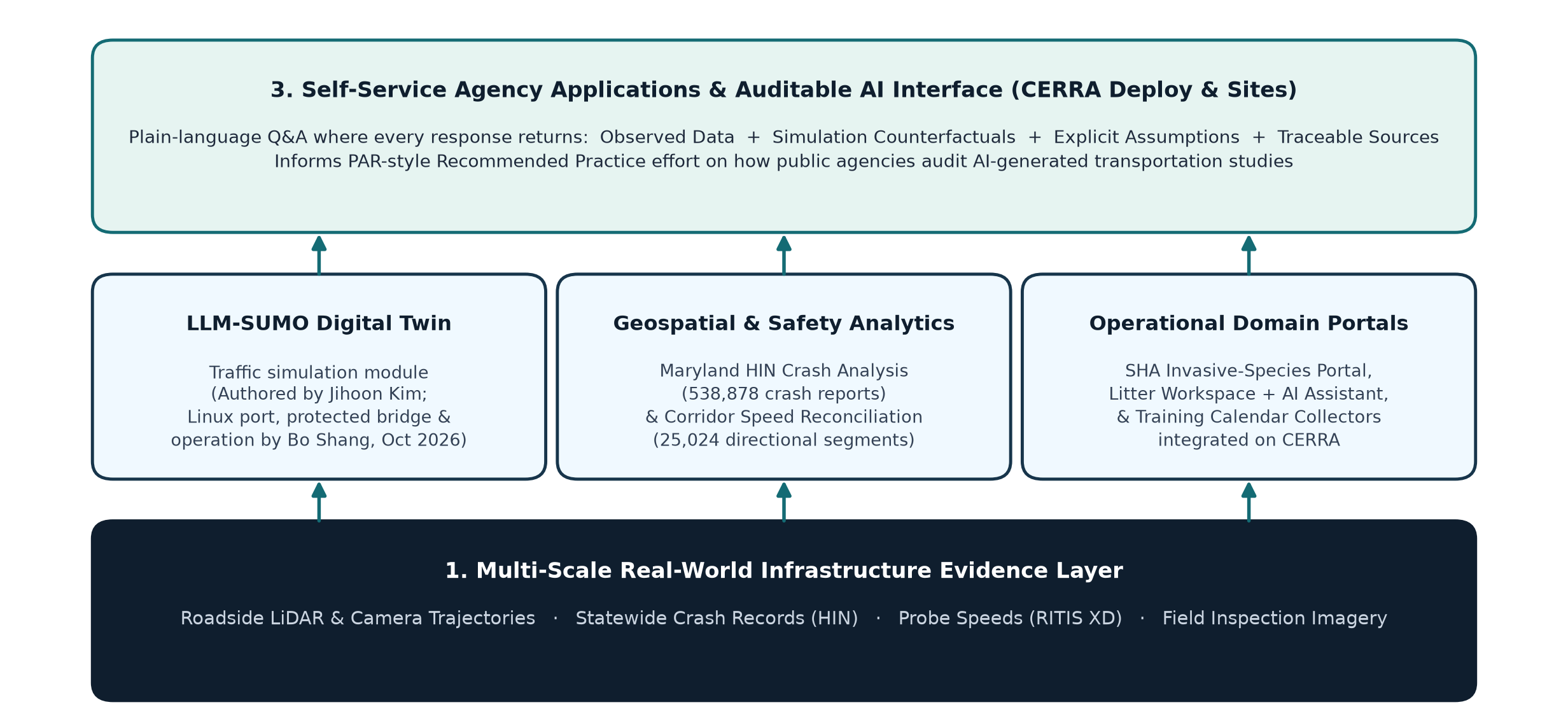
Platform Contribution & Collaborative Attribution: Designed, built, and operated CERRA (Civil, Environmental, Road & Resource Analytics, cerra.cloud) including Deploy & Sites self-service publishing—bringing collaborative M-TRAIL tools and datasets (LLM-SUMO by J. Kim; HIN method by Y. Gong / pilot by K. Chai; SHA portal & litter model by L. Cheng's team) into unified operation.
LLM-SUMO Traffic Digital Twin & Auditable AI Standards
LLM-SUMO Integration on CERRA (Live Oct 2026)
- CERRA itself is the geospatial platform; inside it, LLM-SUMO serves as a working traffic-simulation digital twin.
- Authored by Jihoon Kim; ported to Linux, connected via a protected execution bridge, packaged as a CERRA module, and operated by Bo Shang.
- Converts natural-language prompts into calibrated SUMO network scenarios, executes runs, and summarizes traffic impacts for engineers.
Auditable Decision Support & PAR Standard
- Joins empirical before/after corridor records (e.g., 25,024 directional XD speed segments & HIN crash data) with SUMO counterfactuals.
- Every copilot response must return four elements: Observed Data + Simulation Result + Explicit Assumptions + Sources.
- Observing real failure modes motivated leading a PAR-style Recommended Practice effort on how agencies audit AI-generated traffic studies.
Engineering Boundary
AI-driven simulation explores counterfactuals—it does not replace the traffic engineer. A decision or study an operator cannot audit is a decision a public agency will not deploy.
Feasibility-Preserving Routing on Quantum Hardware & Quantum-Safe V2X
Feasibility-Preserving VRP on IBM Heron (Oct 2026)
- Penalty-based QUBO encodings often return infeasible routes when solver noise increases.
- Formulated vehicle-routing problems in feasibility-preserving encodings and benchmarked them across classical GA/SA solvers, quantum simulators, and an IBM Heron superconducting processor.
- Honest Empirical Finding: At tested hardware scale, quantum execution shows no advantage over classical baselines; the enduring contribution is the structural feasibility guarantee.
Quantum-Safe V2X Signal Broadcast & Agent Eval
- Evaluates post-quantum cryptographic authentication overhead on roadside SPaT (Signal Phase & Timing) broadcasts so cooperative safety stays trustworthy under strict V2I latency budgets.
- Applies reproducible evaluation (versioned configs, counterbalanced replay, regression guardrails) to tool-using AI agents—documented in open research notes.
Generalizable Lesson Across Physical & Algorithmic Systems
Problem structure—occlusion geometry at intersections, feasibility encodings in routing, and source provenance in AI—rather than raw compute or sensor count is usually the binding constraint in field deployment.
Research Agenda, Teaching & Mentoring
Advancing deployment-grade field robots, open cooperative-perception benchmarks, and auditable autonomy while training the next generation of engineers.
Deployment-grade inspection & active-SLAM field robots
Network-scale PACO & open InfraLiDAR-Eval suite
Auditable fleet & infrastructure decision systems
Three Connected Thrusts Across Scales & Target Funding
Thrust 1 · Micro (Proposed)
Deployment-Grade Field Robots
- Combine flight/surface mobility, contact sensing & 3D defect analytics with inspector-in-the-loop reports.
- Proposals in preparation: quadruped work-zone inspection via active SLAM (cone/barrier localization) & rural medical drone delivery (with MDOT).
- Milestones: Multi-structure agency demos & open defect shift benchmark (Yrs 1–3).
Thrust 2 · Meso & Macro (Proposed)
Cooperative Perception & Eval
- Extend PACO from single intersections to sensor networks optimizing multi-RSU placement.
- Release InfraLiDAR-Eval as an open evaluation suite quantifying operating envelopes under beam loss, weather & GPS denial.
- Milestones: Open evaluation suite (Yrs 1–2); municipal field pilot (Yrs 2–4).
Thrust 3 · City & Network (Proposed)
Decisions an Operator Can Audit
- Unify feasibility-preserving fleet/inspection scheduling with calibrated digital twins on CERRA.
- Establish PAR-style auditability metrics so human operators can inspect, override, and defend AI studies.
- Milestones: Autonomous inspection dispatch pilots (Yrs 1–3); transit/logistics routing studies (Yrs 2–5).
Funding Roadmap & Agency Translation
Targets: NSF (CPS, Foundational Research in Robotics, CAREER), U.S. DOT & UTC program, FHWA, PHMSA, and DOE—building directly on co-authored U.S. DOT UTC (2026), INSPIRE-024 (2024), and PHMSA CAAP (2022) federal deliverables.
Classroom & Laboratory Teaching Grounded in Real Robotic Systems
Multi-Institution Teaching Record
- Vaughn College (2024, Adjunct Faculty & Summer Instructor):
MCE 355 (Robotics, Mechanics & Control), SBC 012/014A (Principles of AI / Research-AI), and 5-lecture, 5-lab Summer AI Engineering module. - CCNY / CUNY (2023, Adjunct Assistant Professor):
ENGR 204 Electric Circuits (mean student evaluation: 4.2 / 5.0). - UC Merced (2016–2017, Lecturer):
ME 190 Mechatronics, ME 143 UAS (initial lab development), ME 021 Engineering Computing.
Pedagogy & Proposed Course Offerings
- Pedagogy: Connect analytical models to hardware-in-the-loop failure modes; credentialed with ACUE Effective Teaching Certificate (2021) & FAA Part 107 Remote Pilot Certificate.
- Proposed Courses (Adaptable to Department Needs):
- [UG Core] Mechatronics, Controls & Embedded Systems
- [UG/Grad] Autonomous Field Robotics & Vision-Based Control
- [Graduate] 3D Perception, Cooperative Sensing & Auditable AI for Intelligent Infrastructure
Coursework-to-Field Pipeline
Open-source benchmarks (Simscape/OS4 quadrotor suites, InfraLiDAR-Eval crops, SUMO scenarios) bring real sensor datasets directly into student lab assignments and capstone projects.
Inclusive Student Mentoring & Verifiable Engineering Impact
Mentoring & Broadening Participation
- Scoped, Publishable Student Sub-Projects: Sensor bring-up, calibration toolchains, field campaigns, control benchmarks, and reproducible evaluation harnesses.
- Proven Track Record in Diverse Classrooms & Labs: Mentored undergraduate, master's, and high-school researchers at minority-serving and public institutions (Vaughn >85% HSI, CCNY, Missouri S&T).
- Robotics Outreach: Coached FIRST Robotics Competition teams (2022) and judged middle/high-school & collegiate VEX Robotics tournaments (2024).
Selected Scholarly & Engineering Outputs
- 8 Journal Articles: IEEE OJ-ITS ('26), IEEE T-ASE ('25, presented at IROS '25), JCSHM ('25), CBM ('25), Materials Evaluation ('23), Nonlinear Dynamics ('19).
- 16 Conference Papers: IEEE/CVF CVPRW ('26), MobiSPC ('25 ×2), ICUAS ('16, '17), ICARCV ('18), ASME IDETC ('17, '19).
- Federal Deliverables: U.S. DOT UTC DOT 91974 ('26), INSPIRE-024 ('24), PHMSA CAAP ('22).
- Patents & Honors: U.S. Patent 12,296,994 B2 ('25), CN Patent 102427464 B; BIRDS selected for ASCE 2025 Charles Pankow Award; IARC Best Control & Mission Planning Awards.
Resilient Intelligent Infrastructure Across Scales
Micro (~ m) · Structures
Physics-grounded flight control & dual-mode / climbing robots that inspect bridges and concrete before failure.
Meso & Macro · Roads
Elevated roadside LiDAR resolving the 0.61 onboard occlusion ceiling (PACO) & 61.9-h continuous corridor analytics.
City & Network · Decisions
CERRA geospatial AI, LLM-SUMO simulation, and feasibility-preserving optimization that operators can audit.
Thank You · Questions & Collaboration
Bo Shang, Ph.D. · Postdoctoral Associate, University of Maryland (CEE & M-TRAIL)
Email: bshang@umd.edu ·
Academic CV: /cv/ ·
Research Scientist Resume: /cv/research/ ·
Download: PDF / PPTX