CITY SCALE · UMD M-TRAIL & MTI · LIVE AT CERRA.CLOUD
CERRA: Auditable Geospatial AI & Traffic Simulation for Public Agencies
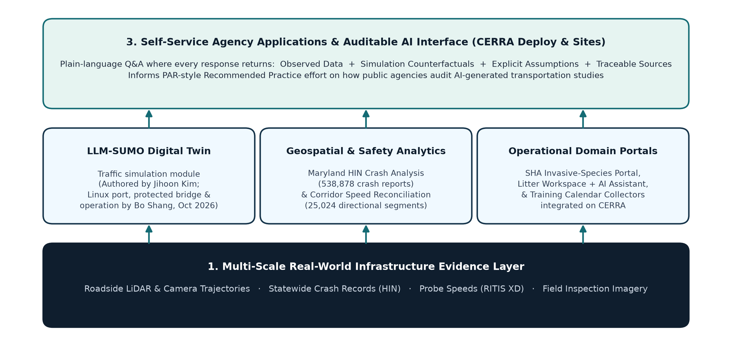
Public transportation agencies cannot make signal-timing, work-zone, or freight-corridor decisions from opaque black-box LLM chat replies. Built and operated at the University of Maryland, CERRA pairs real corridor telemetry with a protected LLM-SUMO microscopic simulation bridge — returning observed metrics, simulated counterfactuals, explicit assumptions, and verifiable data sources side by side.
NO HALLUCINATED TRAFFIC ENGINEERING
The Four-Part Auditable Decision Output
CERRA is an AI-driven geospatial research platform built for public agencies at UMD M-TRAIL (under Prof. Xianfeng Yang). Rather than asking a language model to guess queue lengths, CERRA translates natural-language corridor questions into deterministic data queries and sandboxed SUMO simulation runs.
CERRA Geospatial Layer
Ingests multi-agency traffic, weather, incident, and infrastructure asset layers into an interactive web map built and operated by Bo Shang at UMD.
LLM-SUMO Integration
Traffic-simulation digital twin authored by M-TRAIL colleague Jihoon Kim; ported to Linux, wired through a protected execution bridge, packaged, and operated in production inside CERRA by Bo Shang (Oct 2026).
PAR Recommended Practice
Integrates Perceived Acceleration Rate (PAR) corridor stability diagnostics alongside travel-time and queue metrics for mixed heavy-truck traffic.
Quantum-Safe & QPU Eval
Evaluates post-quantum V2I signal broadcast latency overhead and feasibility-preserving Vehicle Routing Problem (VRP) encodings on IBM Heron hardware.
LIVE DEPLOYMENTS & RIGOROUS BENCHMARKING
Deployed Modules & Hardware Findings
CERRA & LLM-SUMO Web Deployment
Feasibility-Preserving VRP Encoding on IBM Heron Superconducting QPU
MULTI-SCALE PORTFOLIO
Explore Other Deployed Systems
BIRDS Hybrid Bridge Robot
Patented drone + motorized girder-clamping robot with 1.3 s autonomous flange capture, Jetson RGB-D vision, and ...
View System Architecture Meso · Cooperative V2I LiDARPACO & V2I Safety Auditor
Physics-grounded intersection observability engine (0.37 ADAS → 1.00 V2I) and sub-meter PET/TTC near-miss audito...
View System Architecture Macro · Continuous Corridor SensingHighway LiDAR Sync & InfraLiDAR-Eval
61.9-hour roadside 3D LiDAR + RGB synchronization, multi-sweep reconstruction, and NYSDOT I-95 corridor evaluati...
View System Architecture Micro · Climbing Robot & 3D NDTConcrete 3D Defect Analytics
Wall-climbing robot + iPad TestFlight app + AWS Lambda CNN + WebODM 3D mesh registration for millimeter-scale co...
View System Architecture Micro · Robust Flight ControlFractional-Order UAV Servoing
Iso-damping fractional-order PD^μ quadrotor visual servoing (0.933 s vs. 0.546 s max sampling period) with live ...
View System Architecture Full-Stack AI Product · 0-to-1ScholarMind AI Platform
Bilingual AI research & education platform with Claude + self-hosted Qwen/Ollama agents, 34 courses, and a 34-no...
View System Architecture